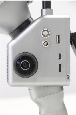
Geosun gAirHawk Sesries GS-100C+ Sistema de escaneo LiDAR Recopilación de datos 3D de nivel de entrada Livox Avia Sensor Supprt UAV Drone
Precio: Negotiation
MOQ: 1
El tiempo de entrega: 7-10 works days
Marca: Geosun
Destacar:GS 100C Livox Avia LiDAR, gAirHawk Livox Avia LiDAR, Lidar montado en drone de 200 HZ
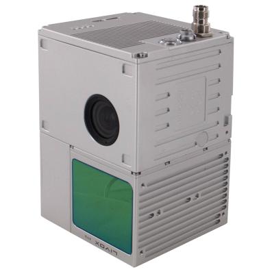
Sistema de escaneo LiDAR GS-100C+ Recopilación de datos 3D de nivel básico Sensor Livox Avia
Geosun gAirHawk Serie GS-100C+ Sistema de escaneo LiDARgAirHawk GS-100C+ es un tipo de sistema de adquisición de datos de nube de puntos LiDAR ligero y compacto, escáner láser Livox de nueva g... Ver más
➤ Visitar Sitio web
Drone Lidar Scanner Geosun GS-130X Escaneo 3D Cámara RGB incorporada Solución aérea total DJI M300 Rentable
Precio: Negotiation
MOQ: 1
El tiempo de entrega: 10-15 works days
Marca: Geosun
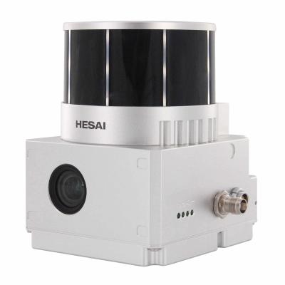
Destacar:Sistemas del Lidar del UAV de 1, 6 km2, Sistemas del Lidar del UAV de HESAI XT, Sensor del lidar del uav de HESAI XT
Drone Lidar Scanner Geosun GS-130X Escaneo 3D Cámara RGB incorporada Solución aérea total DJI M300 Rentable
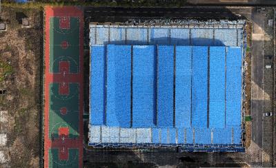
Aplicación del sistema de escaneo UAV LiDAR
Dron con LiDAR (DJI M300 y GS-130X)
... Ver más
➤ Visitar Sitio web

Sistema LiDAR de recopilación de información vial gCollector-M502 en aplicación urbana 3D
Precio: USD 100,000.00/Unit
MOQ: 1
El tiempo de entrega: 10-15 works days
Marca: Geosun
Destacar:Sistema LiDAR de recopilación de información en la carretera, sistema LiDAR de aplicación Urban 3D
Sistema de escaneo LiDAR de recopilación de información gcollector-m502 El sistema de recopilación de información en carretera GCollector-M502 esUn sistema de recolección móvil real escaso que integra LiDAR, cámaras panorámicas, GNSS, IMU, WS y PC juntos. Se puede montar en automóviles, trenes o bar... Ver más
➤ Visitar Sitio web

Sistema de monitoreo de deformación GNSS de precisión de 1 mm
MOQ: 2
El tiempo de entrega: 10-15 works days
Marca: Geosun
Destacar:Sistema de monitoreo GNSS de 1 mm Geosun, sistema de monitoreo de deformación GNSS de 1 mm, sistema de monitoreo de deformación de gráficos 3D
Receptor GNSS de levantamiento de alto rendimiento, estación de referencia CORS, sistema de monitoreo de deformaciones
Geosun gMOS es un sistema de monitoreo de deformación de alta precisión GNSS en tiempo real que adopta la tecnología global avanzada de posicionamiento dinámico GNSS de alta p... Ver más
➤ Visitar Sitio web

Sistema GPS BDS GLONASS GNSS INS para posicionamiento y altitud
Precio: Negotiation
MOQ: 1
El tiempo de entrega: 5-10 Working Days Since Payment
Marca: Geosun
Destacar:Sistema GLONASS GNSS INS, sistema BDS GNSS INS, sistema GPS GNSS INS
Sistema GPS BDS GLONASS GNSS INS para posicionamiento y altitud
AGS 300Sistema GNSS INS agrega un módulo de navegación inercial (IMU) de alta precisión, sin importar cómo se incline el fuselaje durante el vuelo de aviación, puede proporcionar con precisión información de posición, velocidad y ac... Ver más
➤ Visitar Sitio web

Software de procesamiento de trayectoria Geosun GNSS INS Shuttle
Precio: Free
MOQ: 1
El tiempo de entrega: 1-3 Working Days Since Payment
Marca: Geosun
Destacar:Software de procesamiento de trayectoria GNSS INS, software Geosun Shuttle, software de procesamiento de trayectoria Geosun
Software Shuttle con derecho de propiedad independiente
Software Shuttle con proceso de trayectoria, software GNSS/INS
Shuttle es un software de posprocesamiento de determinación de actitud y posicionamiento GNSS/INS de alta precisión, desarrollado independientemente por Wuhan Geosun Navigation Te... Ver más
➤ Visitar Sitio web
Software de procesamiento de datos 3D LiDAR con salida de archivo PT en color
Precio: Free
MOQ: 1
El tiempo de entrega: 1-3 Working Days Since Payment
Marca: Geosun
Destacar:Software de procesamiento de datos gAirhawk LiDAR, software de procesamiento LiDAR de salida de archivos LAS, software de procesamiento de datos en tiempo real
Introducción a gAirHawk
Software de procesamiento de datos LiDAR 3D con salida de archivos PT en colorgAirHawk es un software de computación en la nube de puntos y monitoreo de adquisición de sistemas de escaneo lidar de... Ver más
➤ Visitar Sitio web
Solución PPK
(1)
Fotografía Topografía Posicionamiento diferencial cinemático Solución PPK
Precio: Negotiation
MOQ: 1
El tiempo de entrega: 5-10 Working Days Since Payment
Marca: Geosun
Destacar:Fotografía Solución PPK para topografía, Solución PPK de posicionamiento diferencial cinemático, Instrumentos AG213 PPK
Receptor AGS 213
Aplicación de PPK Instruments para topografía y cartografía fotográfica
Receptor GNSS aéreo de alto rendimiento
La serie AG213 es fabricada por Geosun espacial y se especializa en la aplicación aérea con bajo consumo de energía y receptor GNSS de alto rendimiento, diseño elaborad... Ver más
➤ Visitar Sitio web
Solución RTK
(2)
ESTACIÓN BASE/ROVER
Precio: Negotiation
MOQ: 1
El tiempo de entrega: 5-10 Working Days Since Payment
Marca: Geosun
Destacar:Receptor GPS Solución RTK, Instrumento 2G Byte RTK, Solución 2G Byte RTK
Instrumento RTK Instrumentos de topografía y cartografía Receptor GPS
Obtenga una ventaja competitiva con el receptor Easynavtech R7GNSS.El R7 está equipado con tecnología avanzada para garantizarle la máxima productividad en el campo.El diseño duradero IP67 hace posible trabajar en entornos difíci... Ver más
➤ Visitar Sitio web
Drone LiDAR
(2)
Mapeo Topográfico Dron LiDAR de ala fija VTOL con distancia entre ejes de 3400 mm
Precio: Negotiation
MOQ: 1
El tiempo de entrega: 15-20
Marca: Geosun
Destacar:Dron de ala fija Geosun VTOL, dron de 2000 mm de envergadura VTOL LiDAR, dron de 2000 mm de envergadura LiDAR
Aplicación de drones de ala fija VTOL para mapeo y levantamiento
GS-S300 es un dron de ala fija VTOL puramente eléctrico, con un diseño de apariencia simple y suave, que permite que el dron navegue a una velocidad de 90 km/h y tenga una duración efectiva de la batería de 2,5 horas.Se puede equipar ... Ver más
➤ Visitar Sitio web
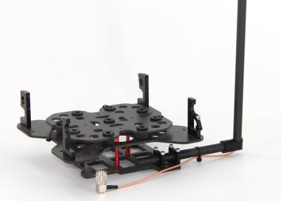
Kits de montaje de drones Geosun DJI M600 Accesorios LiDAR
Precio: USD 500/SET
MOQ: 1
El tiempo de entrega: 1-3 Working Days Since Payment
Marca: Geosun
Destacar:Kits de montaje para drones DJI M600, accesorios LiDAR Geosun, accesorios LiDAR DJI M600
Kits de montaje para DJI M210, M300, M600 Pro y otras marcas.
Los drones DJI son una buena aplicación para levantamientos y mapas, especialmente para DJI M210, M300 y M600 Pro.Es popular y ampliamente utilizado por las aduanas de todo el mundo.
Para combinar con los drones DJI, Geosun ha diseñado ... Ver más
➤ Visitar Sitio web
Sistema de escaneo SLAM LiDAR Mochila Slam Escaneo 3D subterráneo Interior
Precio: Negotiation
MOQ: 1
El tiempo de entrega: 5-7 works days
Marca: Geosun
Destacar:Sistema de escaneo LiDAR UAV de mano, Sistema de escaneo LiDAR UAV de mochila Slam, Sistema de escaneo LiDAR UAV 3D
Sistema de escaneo LiDAR Geosun GFireEye serie GS-100G Algoritmos de golpe HESAI XT16 Mapeo subterráneo Recopilación de datos 3D
Sistema de escaneo LiDAR Geosun gFireEye serie GS-100G
GS-100G es un tipo de sistema de escaneo LiDAR portátil desarrollado independientemente por la empresa Geosun. ... Ver más
➤ Visitar Sitio web